The Urban Heat Island Effect
Redding Nights Are Staying Hot.
That’s a Problem We Built.
Redding has always been hot in the summer. But the heat people experience in Redding is not only a product of weather and geography. How much of the ground is paved, how much tree canopy is left to shade it, and how much open land has been replaced by rooftops and asphalt all affect how much heat the city absorbs during the day and how long it holds onto that heat after dark. Over the past four decades, Redding’s land cover and tree canopy have both changed in ways that make the city hold more heat than it used to.
How Heat Gets Trapped
Anyone who has walked across a parking lot at dusk knows the feeling: the sun is down, but the ground is still radiating heat. Pavement, concrete, and rooftops soak up solar energy all day and stay hot for hours after dark. Pack enough pavement into one area, and the air above it never gets a chance to cool down. Open ground lets heat go. A city full of hard surfaces holds onto it. That difference between developed land and open land is called the urban heat island effect.
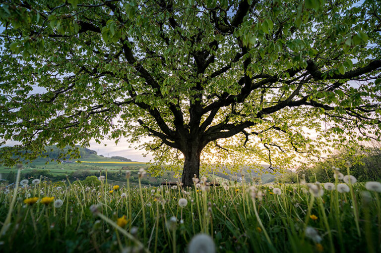
Trees counter that heat in two ways. Tree canopy shades the ground and keeps pavement from absorbing as much solar energy during the day. Tree roots pull water from the soil, and the leaves release that water as vapor, cooling the air around the tree the same way sweat cools skin. When trees are cut down and the ground is paved over, both of those cooling processes stop, and the pavement absorbs and radiates heat with nothing working against it.
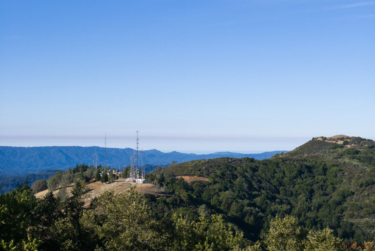
What Redding Used to Look Like
Forty years ago, the edges of the valley floor were open grassland and oak woodland. The ground was not paved. Rain soaked in instead of running off. Scattered trees shaded the soil and kept it from baking in the sun. That kind of landscape cools off fast after dark because the ground is not storing much heat to begin with.
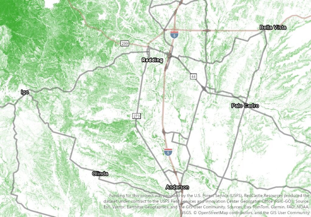
As Redding grew, subdivisions and shopping centers replaced that open ground with rooftops and asphalt. Each new development added more surface area that absorbs heat during the day and radiates it at night. The land cover maps below show how much of that open ground has been converted, decade by decade, from 1985 to 2023.
These five Land Cover maps show the greater Redding area from 1985 to 2023. In each one, red marks developed land, dark green marks forest canopy, and the tan and beige tones are open grassland and bare ground. The first four maps are paired by decade. The last one stands alone because what happened between 2015 and 2023 deserves its own look.
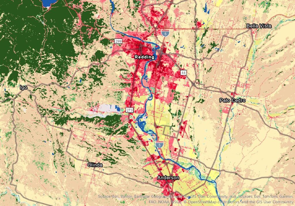
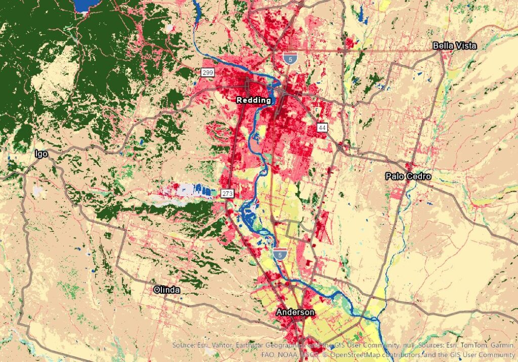
1985 and 1995: In 1985, Redding’s developed footprint is concentrated along Interstate 5 and Highway 44, with open ground separating the city’s edges from Anderson to the south and Palo Cedro to the east. By 1995, the red has thickened along both highway corridors, and new development is visible east toward Palo Cedro. Canopy loss from the 1990 Kanaka Fire, a lightning-caused fire that burned nearly 2,900 acres, is visible in the upper left.
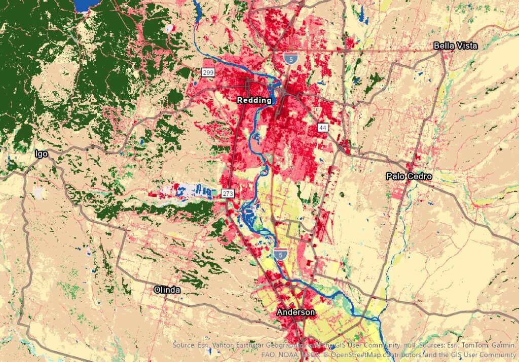
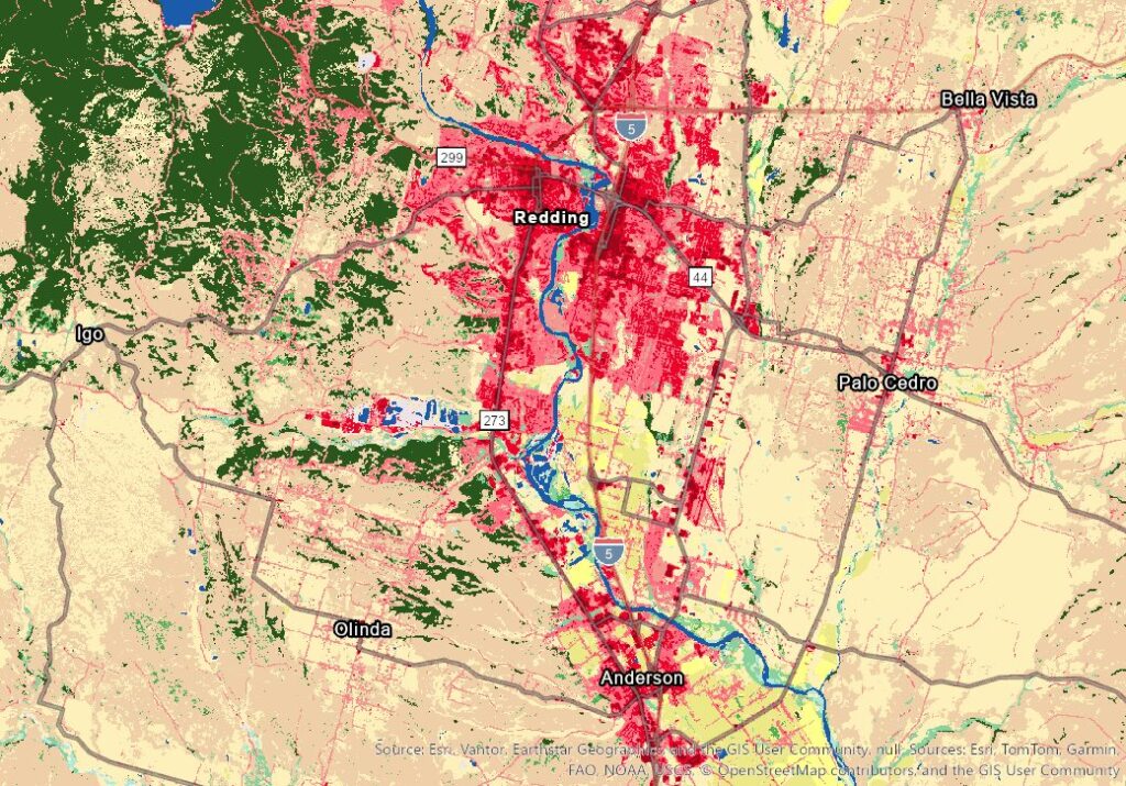
2005 and 2015: By 2005, development east along Highway 44 has spread noticeably toward Palo Cedro. The gap between Redding and Anderson along I-5 is closing as new construction fills in from both directions. The Kanaka Fire scar in the northwest forest has not filled back in, and the canopy around the scar is more broken than before. By 2015, development along I-5 between Redding and Anderson runs almost wall to wall. Growth east toward Palo Cedro has pushed further out from Highway 44. Every part of the map has shifted over thirty years: more red, less green, less open ground.
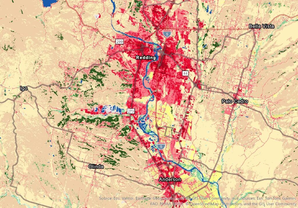
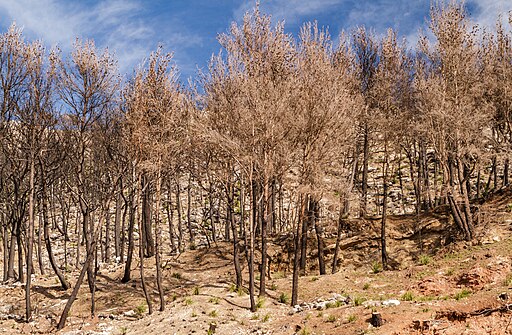
2023: By 2023, development fills most of the valley floor between Redding and Anderson. What was still a visible gap along I-5 in earlier maps is now one developed stretch. The east side toward Palo Cedro has more development than open ground. New construction is visible south of Anderson. 2023 is five years after the 2018 Carr Fire, and the dark green forest is almost entirely gone, replaced by the same tan and beige as the open valley floor. The Kanaka Fire scar that was already visible in 1995 never recovered, and the Carr Fire burned through the canopy around it. Five growing seasons later, the forest has not come back. Development kept expanding while the forest that used to balance the heat from all that pavement disappeared.
Outside of catastrophic fires, the tree canopy does not disappear all at once. It shrinks gradually as trees are removed for construction, lost to drought stress, cut down for insurance reasons, or left unmaintained. When trees come down, few local regulations require them to be replaced. The 2018 Carr Fire burned through canopy in the western corridor in a single event, but even without the fire, the city has been losing trees steadily for decades.
These maps show tree canopy, the overhead shade provided by trees, across the greater Redding area from 1985 to 2023. Green means tree cover. White means no tree cover. Darker green means denser canopy. Where the land cover maps show what replaced open ground, these maps show how much shade the area has lost. Less shade means more pavement and rooftops exposed to direct sun, and more heat stored in the ground.
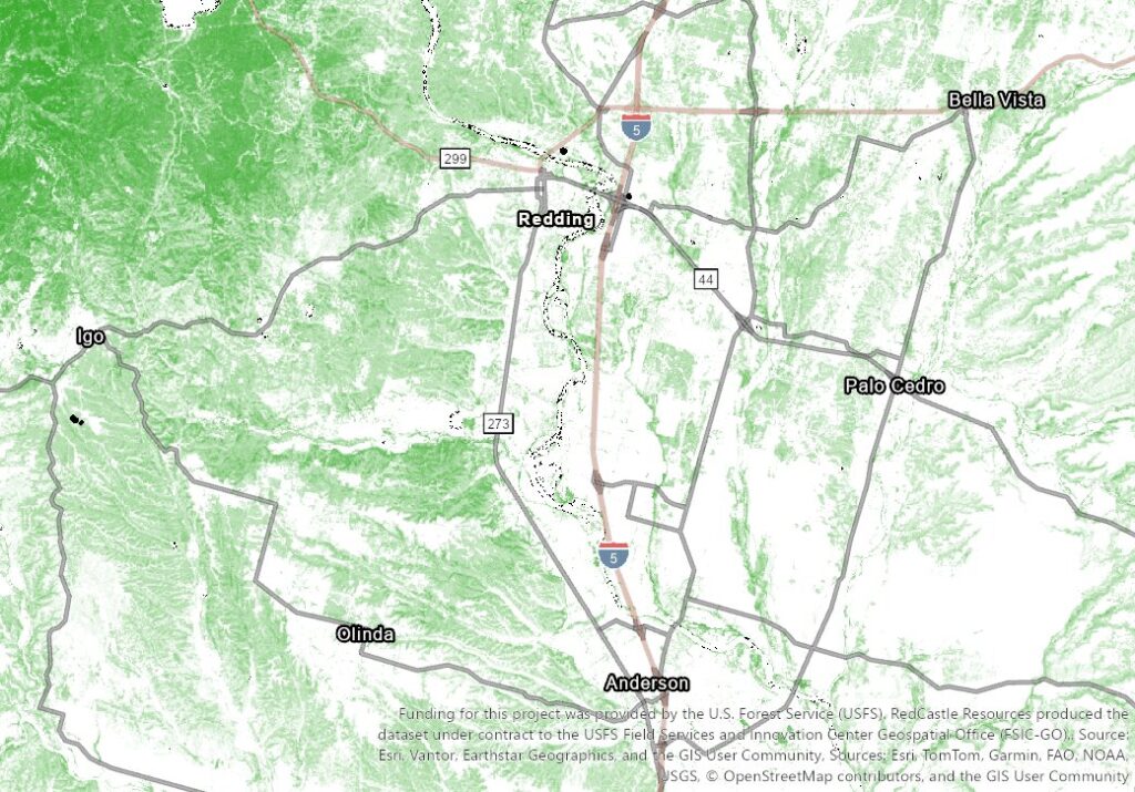
1985 and 1995: In 1985, the densest canopy is in the northwest, where forest covers about 69% of that area. Inside Redding, tree cover is scattered and light, around 25% of the urban core. The I-5 corridor between Redding and Anderson has about 19% canopy. By 1995, most of the map is slightly greener. Canopy across the full map increased from about 32% to 34%. The northwest forest held steady. The river corridor, the southwest toward Olinda, and the Bella Vista area all gained a few points. This is the most canopy the area will have in the entire series.
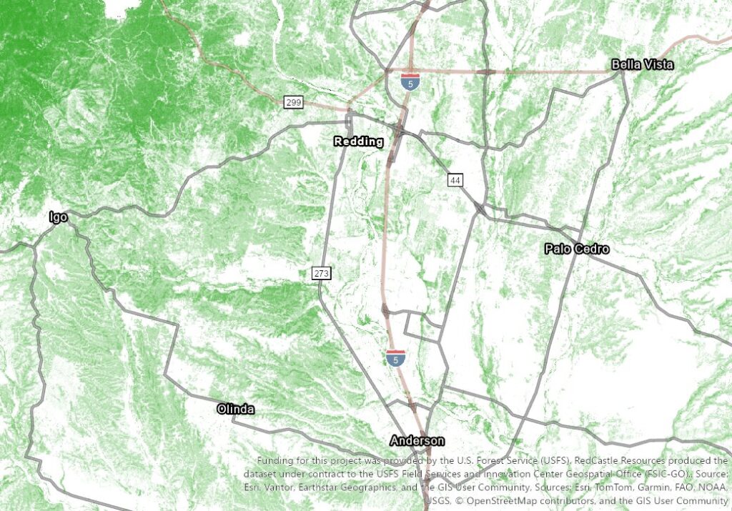
2005 and 2015: By 2005, that gain has reversed. Canopy is declining in the east toward Palo Cedro, which dropped from 20% back to 17%, and around Bella Vista, which fell from 25% to 21%. By 2015, canopy loss has spread across the whole map. The southwest toward Olinda took the biggest hit, dropping from 44% to 30% in a single decade. The urban core dropped from 24% to 21%. The east side toward Palo Cedro is down to 14%. Canopy is disappearing from every part of the map, not just the areas with new construction. Drought, maintenance, and development are all pulling trees out, and nothing is putting them back at the same rate.
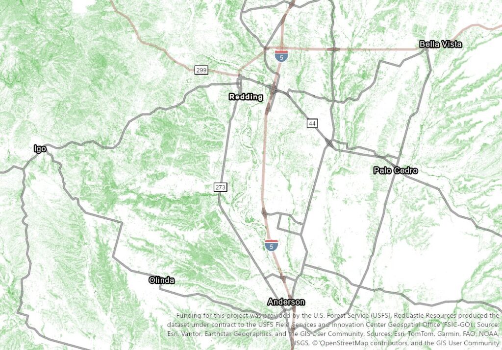
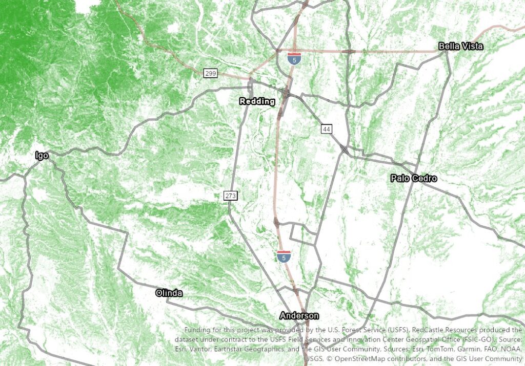
2023: By 2023, the map is visibly lighter than any previous year. The northwest forest canopy has collapsed to 27% after the 2018 Carr Fire. The urban core is down to 14% canopy, almost half of what it had in 1985. The river corridor, which held steady for 20 years around 21%, dropped to 16%. Bella Vista is down to 14%. The south gap between Redding and Anderson lost five points in eight years. Every zone on the map has less shade than it did a decade prior, and most have less than half the dense canopy they started with in 1985. The trees that cool the air and shade the ground are disappearing across the board, and the pace is picking up.
Why Redding Gets Hit Harder
Geography makes the problem worse. Redding sits at the bottom of a valley surrounded by mountains. Coastal cities get relief from ocean breezes that push cooler air in overnight. Redding has no ocean breeze. Hot air settles into the valley and sits. On a still summer night, nothing pushes that hot air out. Heat stored in pavement and rooftops radiates into air that has nowhere to go, and the temperature barely drops before the sun comes up again.
What Happens When Nights Don’t Cool Down
Hot days are hard on the body, but most people recover better when nights cool down. Cooler nights allow body temperature to drop and give the heart and blood system time to recover. When nights stay warm, especially above 70 Fahrenheit, sleep tends to be Less restorative and the body stays under more strain. A single night is uncomfortable, but repeated warm nights can become a serious health stress, especially for older adults, people with chronic conditions, and anyone without effective cooling.
Water systems are affected in a similar way. Rivers usually cool at night because cooler air pulls heat out of the water. When nights stay warm, that cooling slows down, so stream temperatures remain higher. For cold-water fish like salmon, warmer water means less dissolved oxygen and more physiological stress. Sustained warmth can also increase the risk of algae growth and low oxygen events, which can harm fish populations.
Just like humans, plants breathe and burn energy, and when daytime heat makes them work too hard, cool nights let them rest and save the food they created. When soil is dry and rocky, the damp and foggy night air allows the plants to finally soak up moisture through their leaves and roots without the sun evaporating it away. For some plants, if daytime air is too hot for them to open their pores, they wait until the cool night to open up, breathe, and catch moisture safely. If plants can’t recover, they become dead and drying vegetation that is fuel for fire.
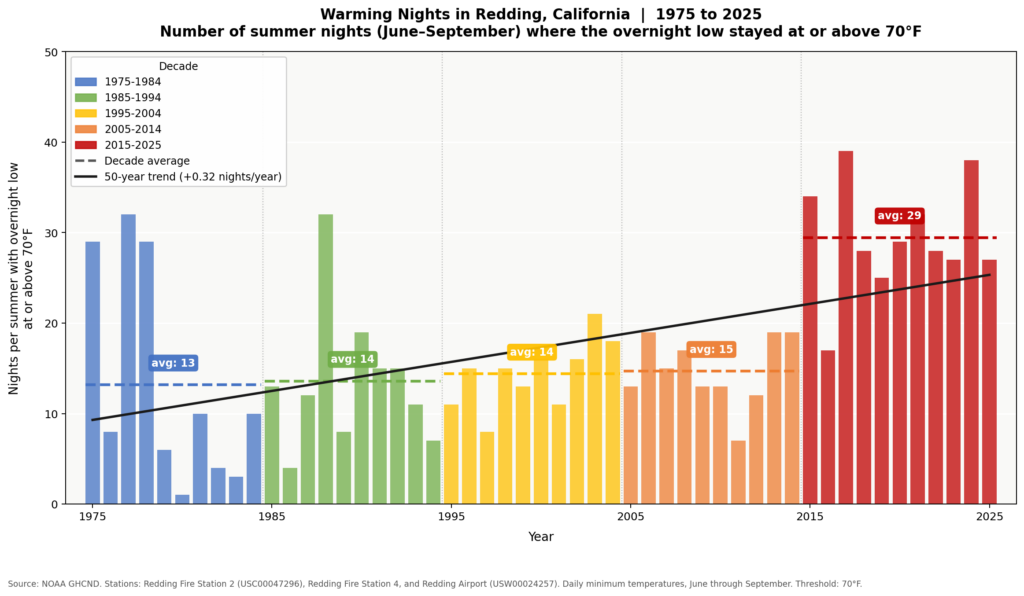
From 1975 through 2014, Redding averaged 13 to 15 of these hot nights per summer. From 2015 through 2025, the average jumped to nearly 30. That is not a gradual trend. The increase is concentrated in the last ten years.
Two Problems at Once
Climate change is raising baseline temperatures in inland Northern California, and Redding cannot solve that alone. But the urban heat island effect is a separate problem that Redding built on top of the climate trend. A warming climate sends more solar energy into the valley. A landscape full of pavement and thin tree cover traps more of that energy overnight. The climate trend makes the local problem worse, and the local problem makes the climate trend hit Redding harder than it would hit a place with more tree cover and less asphalt.
What Can Actually Change
Redding cannot control the climate, but Redding can control what the local landscape looks like. Trees in places like Shasta County as essential infrastructure, not decoration.
The most effective steps are not complicated. Protect the large, established trees that are still standing, because mature trees provide far more cooling than newly planted ones. Plant new trees where the heat is worst: along streets, in parking lots, around buildings. Stop approving large expanses of dark pavement with no shade. Use lighter-colored paving materials that reflect sunlight instead of absorbing it.
Every development decision either adds heat to the landscape or takes heat out of it. Redding has been adding heat for 40 years. The nights show the result. Changing how the city builds going forward is how that pattern starts to reverse.